
Shelf cloud versus wall cloud
Two lowerings. One is the storm breathing out and one is the storm breathing in. Everything about how you report them is different, and this is the call spotters get wrong more than any other.
Why this lesson is twice the size of the others
Because forecast offices keep writing pages about it. NWS Louisville states plainly that shelf clouds "many times... are reported as wall clouds, funnel clouds, or rotation", and that Ragged low cloud that forms in humid air near a storm and drifts about. It rises slowly and does not rotate, which is what separates it from a funnel, and it is the single most common thing mistaken for one. clouds "are often mistakenly called wall clouds or funnel clouds".
Note what that is and is not. It is the National Weather Service saying, qualitatively, that this is a frequent error. No study quantifies it, and you should be suspicious of anyone who gives you a percentage for it. What it is enough to justify is spending thirty minutes here instead of fifteen.
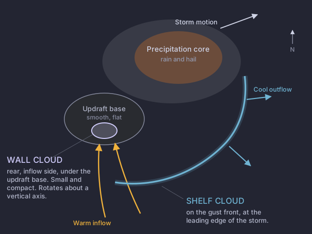
The definition, in full
The Field Guide glossary on wall clouds, quoted at length because every clause is load-bearing: "A localized, persistent, often abrupt lowering from a The smooth, flat, dark cloud base on the rear flank of a storm, where warm air is flowing in and rising. It is named for the air going up, not for being dry: hail and large drops may still fall from it.... normally are found on the south or southwest (inflow) side of the thunderstorm. When seen from within several miles, many wall clouds exhibit rapid upward motion and cyclonic rotation. However, not all wall clouds rotate. Rotating wall clouds usually develop before strong or violent tornadoes, by anywhere from a few minutes up to nearly an hour."
Two things fall out of that. A A localized, persistent lowering beneath the updraft base, on the rear inflow side of a storm, marking where air is being drawn up. Not all of them rotate, and a rotating one is what you report. is not by itself a Severe weather is happening or about to happen for the people inside a drawn polygon. Issued by the local forecast office. It means act now., because not all of them rotate. And a rotating one can precede a tornado by up to nearly an hour, which is a very long time in this business and the reason a report of one is valuable rather than merely interesting.
Where each one lives
The checklist
Assembled from NWS Louisville, the NWS Fort Worth spotter handout and the Field Guide glossary. The two amber rows are the ones that decide a report.
The axis row is the one worth memorising, because it survives bad light and bad angles better than the others. NWS Louisville puts it directly: a shelf "may appear to rotate on a horizontal axis", whereas "Wall clouds will rotate on a vertical axis, sometimes strongly". A A low, wedge-shaped arcus cloud on the leading edge of a storm, attached to the cloud base above it. It is an outflow feature, it means damaging wind rather than rotation, and it is the feature most often misreported as a wall cloud. tumbling toward you is not rotation in the sense anybody wants reported.
The motion cues come from the NWS Fort Worth handout, and they are the ones to use when you can see the rain: shelf clouds "slope down and away from rain" and "can move far ahead of the rain", while wall clouds "slope down and towards rain", "maintain their position with respect to the rain", and "form under a smooth, flat updraft base".
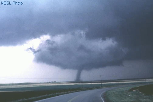
What each one looks like

Three errors to have already made
- The swap itself. Calling a shelf cloud a wall cloud. Almost always a spotter who is looking at the leading edge of a storm and has not asked which side of it they are on.
- "Any lowering is a wall cloud." Scud lowers. Beaver tails lower. Ragged cloud under a gust front lowers. A wall cloud is a persistent, localized lowering from a smooth updraft base, and the other three are not.
- "Every wall cloud gets reported." No. Not all wall clouds rotate, and one that is not rotating, not rising rapidly and not fed by warm inflow is a cloud. Reporting all of them is how an office learns to discount your net.
You are ahead of an approaching storm. A long, low, wedge-shaped lowering spans the horizon, tilting downward away from the rain behind it, and it is running out ahead of the precipitation. The wind at your back has just picked up sharply, blowing from the storm toward you. Report?
Four cues are given: your position, the slope direction, the motion relative to the rain, and the wind direction. All four agree.Every cue points the same way. You are on the leading edge, the feature slopes away from the rain, it is outrunning the precipitation, and the wind is blowing from the storm toward you. That is outflow, so it is a shelf cloud, and a shelf cloud is never reported as rotation. It is still worth a report: damaging straight-line wind is directly behind it.