
How to word it, and where to send it
Seven elements, the location mistake almost everybody makes, three coordinate traps, and which channels exist in 2026.
The seven elements
- Who you are. Trained spotter, and your affiliation or ID if you have one. This sets how the report is weighted before anything else in it is read.
- What. The event, in the vocabulary of lessons 2 to 4.
- Where. The location of the event, which is covered below because it is where reports go wrong.
- When. The occurrence time, with the zone. Lesson 5.
- Movement. Direction and rough speed, if you can see it. This is what turns an observation into something predictive.
- Measured or estimated. For every number in the report.
- Source. First-hand, or relayed from somebody else. A relayed report is welcome and it must be labelled.
Where the event is, not where you are
The field guide puts this in one sentence: "make sure you report the event location and not your location." It is the most common error in spotter reporting and it is getting worse, because a phone will happily attach your coordinates to anything.
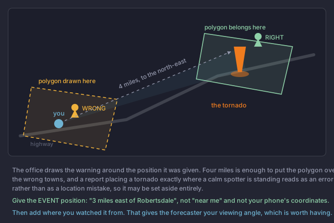
So give the event position the way a forecaster can plot it instantly. In rough order of usefulness:
- Distance and direction from a known town. "Three miles east of Robertsdale." This is the format the products themselves use and it needs no conversion.
- An intersection or landmark, if it is one somebody outside your neighbourhood would find.
- Latitude and longitude in Latitude and longitude written as plain decimals, 30.3304 rather than 30 degrees 19 minutes. The format the record uses, out to four decimal places. Longitudes west of Greenwich are negative, and the missing minus sign is a common reporting error., if you can read them off something reliable. The record accepts a precision out to four decimal places, which is finer than you can estimate a tornado position anyway.
Two reports of the same tornado
Weak:
  "There is a big tornado near me right now, it looks bad."

Usable:
  "Trained spotter. Tornado on the ground 3 miles east of
   Robertsdale, moving north-east around 30 miles an hour.
   Observed at 6:21 PM Central from 2 miles south-west.
   Debris in the air. Estimated, not measured."
Notice what the second version does with uncertainty: it says where the observer was, so the forecaster can judge the viewing angle, and it tags the numbers as estimated. The field guide models the same habit with a phrase worth borrowing outright: "A rotating condensation funnel hanging from a storm base with no ground contact and no debris beneath it. Reportable, and a different report from a tornado.; no debris visible at the surface, but too far away to be certain it is not on the ground." That is not hedging. It is telling the forecaster exactly how much to trust you, which is itself information.
Photographs
- Put something of known size beside the hail. A coin or a ruler. This is the single highest-value thing you can do with a camera.
- Say which way you were looking, since a photograph carries no bearing that a forecaster can see.
- Leave the timestamp and location metadata on. The office uses it, and stripping it removes the part that makes the photograph evidence.
- Say explicitly that they may use it. Non-NOAA imagery needs attribution, and a clear permission saves somebody a phone call during a warning.
Channels that exist in 2026
Which channel to prefer is an office preference and the mechanics of nets and relays are module 10. What belongs here is which paths exist, and more usefully, which two do not.
Which of these locations is unusable as written, anywhere in the United States?
Compare the two coordinate pairs character by character.The first pair has lost its minus sign. Every US longitude is west of Greenwich and therefore negative; entered positive, this one plots on the other side of the world. The other three all place the event unambiguously, and the distance-and-direction form is the one the products themselves use.