
The beam, the curve and the holes
Why the radar sees higher and coarser the further out it looks, what sits directly overhead that it cannot see at all, and how to spot an echo that is not weather.
The numbers are in module 1
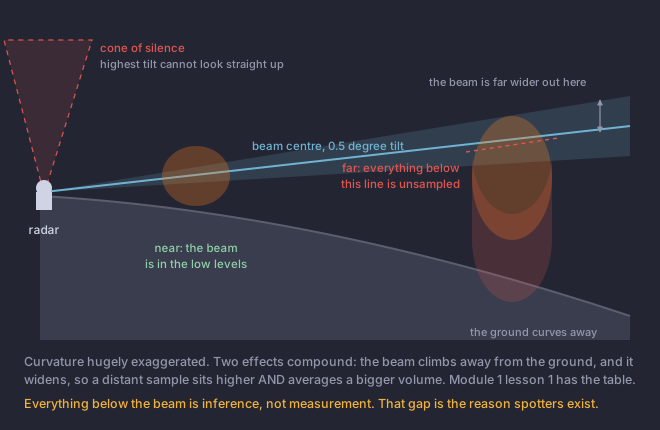
Module 1 lesson 1 carries the beam-height table and it is the course authority for those figures. Go and read it again if the numbers are not in your head: the short version is that a beam leaving the antenna at half a degree is about 1,900 feet up at 50 km and about 8,600 feet up at 150 km, because the earth curves away underneath a beam that travels almost straight.
Beam broadening
The beam is a cone about 0.95 degrees across, not a line. At 25 km that cone is a few hundred metres wide; at the edge of range it is several kilometres. Whatever the radar reports for a point is an average over that whole volume.
So a small feature loses its signature with distance even when the feature itself has not weakened. A tornado a few hundred metres across occupies a sliver of a sample volume kilometres wide, and it is averaged in with the quiet air around it. This is the single most important fact behind lesson 6, and it is why the same circulation produces a dramatic signature near the radar and almost nothing at range.
The hole directly overhead
The holes between radars
Maddox and colleagues mapped this in 2002 and the result is uncomfortable: substantial parts of the contiguous United States have no radar coverage below 1, 2 and even 3 kilometres above ground. The gaps are not evenly distributed, and where you live determines how much of this module applies to you.
Find your nearest site and your distance to it. That single number tells you more about how much to trust the radar picture over your own town than anything else in this module.
Four ways the picture lies
- Ground clutter
- Returns from buildings, terrain and trees near the site, showing as a persistent blotch around the radar that does not move. Filtered out in normal operation, and it reappears when conditions change.
- Anomalous propagation
- When a temperature inversion bends the beam downward more than usual, it strikes the ground far from the site and returns echoes that look like precipitation. Classic on clear calm nights and mornings: a ragged ring or patch of apparent rain that is not there, often over the same ground each time.
- Beam blockage
- Terrain or structures between the radar and the target remove part of the beam. Produces permanent radial wedges of missing or reduced data, in fixed directions, and it is a large part of why western coverage is what it is.
- Non-meteorological targets
- Birds, bats, insects, chaff, smoke plumes and wind turbines all return energy. Lesson 7 gives you the field that separates most of these from weather in one glance.
A tornado-warned supercell is passing almost directly over a WSR-88D site. What happens to the radar picture of it?
The radar has a highest tilt as well as a lowest one.The highest tilt is around 19.5 degrees, so directly overhead there is an unsampled cone. A storm over the site loses its upper structure on the display exactly when it is closest. Beam broadening works the other way from the third option: it smears small features out at long range, and is at its least harmful near the radar.