
Why the rain stops moving
Rate times duration. The ingredients that set the rate, the configurations that stretch the duration, and why the storm that floods you is often the quiet one.
Rate times duration
Doswell, Brooks and Maddox reduced Flooding that begins within about six hours of whatever caused it, counted from the causative event rather than from when anyone noticed the water. The cause is usually intense rainfall, but a dam failure, a levee failure or an ice jam qualifies and can do it on a clear day. forecasting to one paragraph in 1996, and thirty years later it is still the frame everybody uses:
Heavy precipitation is the result of sustained high rainfall rates.
In turn, high rainfall rates involve the rapid ascent of air
containing substantial water vapor and also depend on the
precipitation efficiency. The duration of an event is associated with
its speed of movement and the size of the system causing the event
along the direction of system movement.
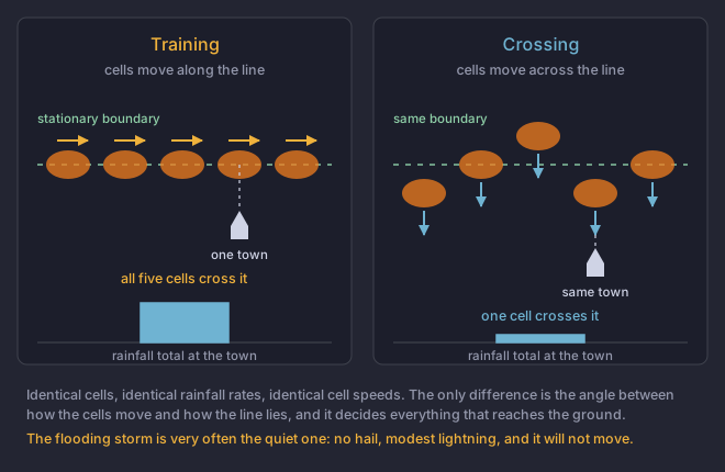
Unpacked, that is two multiplications. The rate is ascent times moisture times The fraction of the water vapour drawn into an updraft that reaches the ground as rain, rather than being carried away in the anvil or evaporated. One of the three terms that set rainfall rate.. The total at a point is that rate times how long the rain sits over the point. Nothing else enters it. A storm with a spectacular rate that crosses you in eight minutes leaves less water than a mediocre one that will not move.
The three ways duration gets stretched
- Slow system motion
- The simplest case. The Mesoscale Convective SystemA collection of thunderstorms behaving as one system rather than as separate storms. Clusters, squall lines and bow echoes are all examples. is moving at ten miles an hour instead of forty, so every point underneath it spends four times as long in the rain. A pair of vectors estimating where a storm system will go, by adding the direction new cells keep forming in to the direction the existing ones are being carried. One end of the idea is a stalled flood-maker, the other is a fast-moving wind event. are how a forecaster anticipates this from a A vertical profile of temperature, moisture and wind through the atmosphere, from a weather balloon or a model. Everything in this section is read off one., and a slow forecast motion in a discussion is a flood signal before any rain has fallen.
- Training echoes
- Individual cells moving along a line that is itself stationary, so cell after cell crosses the same ground like carriages over a level crossing. Each cell is brief. The point underneath them is in rain for hours. This is the configuration that produces the worst totals in the Southeast.
- Backbuilding
- New cells forming repeatedly on the upwind flank, so the system regenerates at its rear as fast as it decays at its front and the whole thing stays put over the ground even though every cell in it is moving. Quasi-stationary MCSs usually do this.
Rain grown by droplets colliding and merging in a deep cloud layer above freezing, with no ice stage involved. Efficient, fast, and the reason a storm with no hail and modest lightning can out-rain a violent one., and the storm that floods quietly
Most of what you have learned about severe storms is about ice. Hail needs a The height at which the air reaches 0 °C. A hailstone has to survive the fall from there to the ground, so a high freezing level means more melting and smaller hail at the surface. and a deep cold layer above it; lightning needs Soft, opaque ice pellets formed when supercooled droplets freeze onto a falling ice crystal. Collisions between graupel and ice crystals are what separate charge and make a storm electrified. colliding with ice crystals. Warm rain skips all of that. In a cloud with a deep warm layer below the freezing level and high humidity through it, droplets grow by collision and coalescence, simply by bumping into one another, and they do it fast.
The consequence is high precipitation efficiency: a larger share of the water vapour drawn into the The column of rising air inside a storm. Everything a thunderstorm does, from hail to tornadoes, is downstream of how strong and how organised this is. reaches the ground as rain instead of being carried off in the The flat, spreading top of a thunderstorm, where the updraft has run out of buoyancy and is pushed sideways by the winds aloft. An anvil left behind by a storm that has died is an orphan anvil.. A warm rain storm can out-rain a much more violent cold-topped one while producing modest lightning, no hail, and nothing that looks alarming.
The Maddox patterns
Maddox, Chappell and Hoxit examined more than 150 intense convective precipitation events in 1979 and found that they were not random. The events sorted into a small number of recurring synoptic patterns, which meant a forecaster could recognise a flood setup the day before rather than the hour after.
- Synoptic, tied to a slow-moving frontal system aloft.
- Frontal, with convection repeatedly firing along a stalled surface boundary.
- Mesohigh, where a previous storm complex has left an The edge of a storm's cold pool, still travelling hours after the storm that made it has gone. New storms often form along one, which is why a dead cell is still worth watching. that the next round trains along.
- A separate western type, driven by terrain, which does not apply here.
What all of them share is more useful than the categories: convective heavy rain, very high surface dewpoints, a deep moist layer, and weak to moderate cloud-layer Change of wind with height, measured as the difference between the wind at the top and bottom of a layer. It is not needed to make a thunderstorm and it decides almost everything about what kind you get.. That last one is the counter-intuitive item. Strong shear is what module 2 taught you to look for in a severe setup, and strong shear also ventilates a storm and moves it along. The flood setup is the one where the shear is not doing that.
One ingredient the framework treats as given is the ground. How wet the ground was before the rain started. It decides how much of the rain becomes runoff, which is why the same storm floods a catchment one week and not the next. decides how much of the rain becomes The share of rainfall that flows across the surface instead of soaking in. Decided by rainfall rate against infiltration rate, by how wet the ground already was, and permanently by how much of it is paved. instead of soaking in, and Roof, road and car park: ground that converts rain to runoff immediately. NWS material puts urban runoff at roughly two to six times what the same rain produces on natural terrain. decides it permanently: NWS material puts urban runoff at roughly two to six times what the same rain would produce on natural terrain. The same storm over the same town floods it or does not, depending on what fell last week.
Two storms drop rain at the same peak rate over the same town. Storm A is a fast, high-topped supercell with large hail. Storm B is a slow line of cells training along a stalled boundary, no hail, modest lightning. Which is the larger flood threat?
The two multiplications from the start of the lesson. One of them has been held constant here by the wording of the question.The rate is given as equal, so the total is decided entirely by duration, and training along a stalled boundary is the configuration that stretches it furthest. Doswell and colleagues, citing Chappell, found slow system movement dominates most flash flood cases. The quiet storm is very often the one that floods.